
Colonial America, 1776 – British Possessions on the Eve of Revolution
About This Map
What it shows
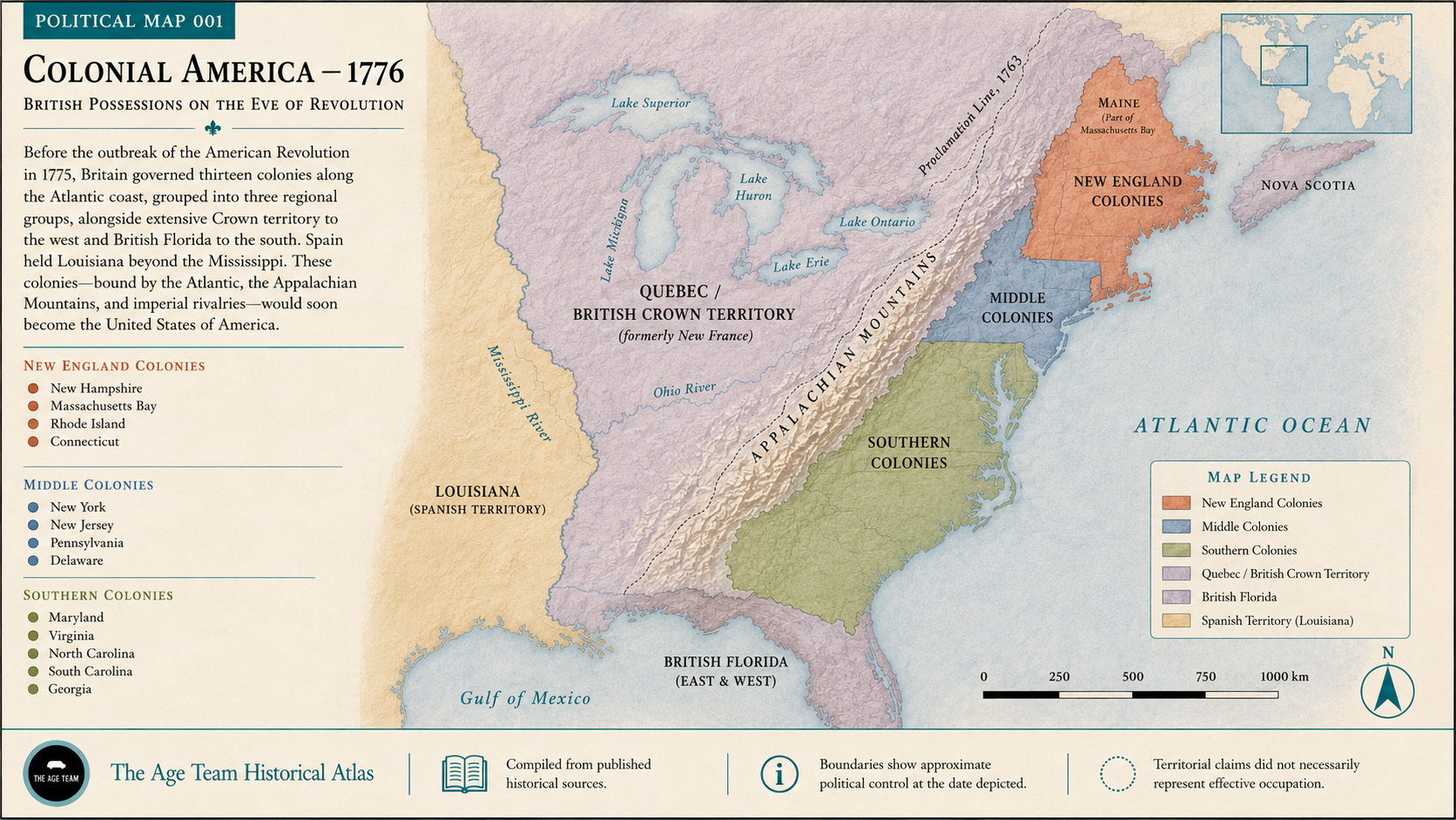
Beyond the Appalachian Mountains lay Crown territory administered from Quebec, with the Proclamation Line of 1763 barring colonial settlement westward. British East and West Florida held the Gulf coast to the south.[1, p. 61]
Quick Facts
The essentials
Quick Facts
Timeline
How it unfolded
10 February 1763
Treaty of Paris Ends the Seven Years' War in America
Britain and France concluded the Treaty of Paris on 10 February 1763[1, p. 61], under which Canada and the Ohio Valley were ceded to the English[3, p. 347]. The Crown's 1763 proclamation then set out to provide for the government of the possessions acquired by this treaty[1, p. 61].
7 October 1763
Royal Proclamation of 1763
The royal proclamation of 7 October 1763 erected four new governments, Quebec, East Florida, West Florida and Grenada, in the territory ceded by the treaty[1, p. 61]. It also defined certain interior boundaries and regulated trade and intercourse with the Indians[1, p. 61].
22 March 1765
Passage of the Stamp Act
Parliament passed the Stamp Act on 22 March 1765[4, p. 38][5, p. 164], taxing deeds and conveyances, college degrees, advertisements and other printed matter[6]. An immense disturbance arose in America, and the act was repealed in March 1766[7, p. 139].
16 December 1773
Boston Tea Party
On the night of 16 December 1773 the Boston Tea Party used 352 chests of tea, with Boston Harbor as the mixing caldron[8]. Parliament answered with the Boston Port Act, which closed the harbor until indemnity for the destroyed tea was paid[4, p. 38].
5 September 1774
First Continental Congress Meets
Delegates from the colonies, Georgia excepted, assembled at Carpenters' Hall in Philadelphia on 5 September 1774 and organised the First Continental Congress[9][10, p. 183]. Its Declaration and Resolves of 14 October 1774 stated the colonies' position against Parliament[1, p. 61].
19 April 1775
Battles of Lexington and Concord
British troops reached Lexington soon after sunrise on 19 April 1775 and found about seventy minutemen drawn up on the green[11, p. 322]. Militia from Massachusetts, Connecticut, New Hampshire and Rhode Island then marched on the British army at Boston[12, p. 31], beginning the siege of the city[13, p. 2].
4 July 1776
Declaration of Independence Adopted
The Second Continental Congress adopted the Declaration of Independence on 4 July 1776, announcing that the Thirteen Colonies, then at war with Great Britain, were no longer part of the British Empire[14]. Congress had voted for independence two days earlier, on 2 July[14].
3 September 1783
Treaty of Paris Recognises the United States
The Treaty of Paris, signed on 3 September 1783 and ratified by Congress on 14 January 1784, formally ended the war between Great Britain and the United States[15]. According to Jefferson, the preliminary treaty of 30 November 1782 had already acknowledged American independence and a western boundary on the Mississippi[16, p. 41].
Dig Deeper
Copy any prompt below into your favourite AI chat to keep exploring.
Explain why Britain's Proclamation Line of 1763, running along the Appalachian Mountains on this map, blocked the same thirteen colonies from settling land they'd just helped win in the French and Indian War, and how that decision helped push them toward declaring independence in 1776.
Argue whether the real fault line on this 1776 map is the Atlantic coastline separating Britain from its colonies, or the Proclamation Line cutting through the Appalachians and separating the colonies from their own future.
Pitch me the Proclamation Line of 1763 like it's the most infuriating property dispute in history: Britain wins the war, grabs the deed to everything past the Appalachians, then tells its own thirteen colonies they still can't move in.
Further Reading
Where to read more
American colonies — Encyclopaedia Britannica
Free, no login. Explains why this map has exactly thirteen units on it — and why the western edge is the vaguest line on the page, since the colonies grew both up the Atlantic coast and inland right up to the Revolution.
Why look at this: Explains, in one clean overview, why this map has exactly thirteen colonial units on it and how the western edge stayed the vaguest line on the page.
https://www.britannica.com/topic/American-coloniesThe American Revolution — Ken Burns, Sarah Botstein & David Schmidt (PBS, 2025)
Six-part, 12-hour documentary tracing the thirteen colonies mapped here from the imperial crisis of the 1760s through the war that turned them into the United States.
Why look at this: Follows the same thirteen colonies from the imperial crisis of the 1760s through to independence — the run-up and the aftermath this map's single 1776 snapshot can only gesture at.
https://www.pbs.org/kenburns/the-american-revolutionThe Theatre of War in North America, with the Roads and a Table of the Distances — Robert Sayer & John Bennett, London, 1776
Free, zoomable scan at the Library of Congress, no login. The 1776 map of the same thirteen colonies drawn from the other side — the commercial sheet Londoners bought to follow the war, complete with a printed table of the colonies' populations.
Why look at this: A free, zoomable scan of the commercial map Londoners themselves were buying in 1776 to follow the same war — worth comparing directly against this one.
https://www.loc.gov/item/74693102/Related
Keep exploring






Can be seen in
Where this shows up

References
Sources
Sources
- BookSelect Charters And Other Documents Illustrative Of American History 1606-1775 by William MacDonald. Page 61. ↑
- BookThe Declaration of Independence of the United States of America by Thomas Jefferson ↑
- BookThe True Benjamin Franklin by Sydney George Fisher. Page 347. ↑
- BookThe French war and the revolution by William Milligan Sloane. Page 38. ↑
- BookThe Continental Army Series: Reality and Aspiration in the American Revolutionary Era by wts@gunjones.com Wm. Thomas Sherman. Page 164. ↑
- BookFamous American Statesmen by Sarah Knowles Bolton ↑
- BookThe autobiography of Benjamin Franklin : with a continuation drawn from his letters : edited for use in… by Benjamin Franklin. Page 139. ↑
- BookWashington the Soldier by Henry B. Carrington ↑
- BookSigners of the Declaration: Historic Places Commemorating the Signing of the Declaration of Independence by Robert G. Ferris ↑
- BookLives of the signers to the Declaration of independence by Charles A. Goodrich. Page 183. ↑
- BookThe Story of the Thirteen Colonies by H. A. Guerber. Page 322. ↑
- BookThe works of John Adams, 2nd pres. of the U.S by Charles Francis Adams. Page 31. ↑
- WebsiteCorrespondence of George Washington as Commander in Chief (America in Class / National Humanities Center). Page 2. ↑
- DocumentUnited States Declaration of Independence ↑
- DocumentTreaty of Paris (1783) ↑
- BookThe Jeffersonian Cyclopedia : a comprehensive collection of the views of Thomas Jefferson by Thomas Jefferson and John P Foley. Page 41. ↑